** Progress in Earth and Planetary Science is the official journal of the Japan Geoscience Union, published in collaboration with its society members.


Gallery View of PEPS Articles
Research
Solid earth sciences
202305202305
Basin-wide erosion and segmentation of the Plio-Pleistocene forearc basin in central Japan revealed by tephro- and biostratigraphy
Masayuki Utsunomiya, Itoko Tamura, Atsushi Nozaki, Terumasa Nakajima
Forearc basin fll, Kazusa group, Kurotaki unconformity, mass-transport deposit, Miura group, Pliocene, submarine landslide, tephra bed, Calcareous nannofossil
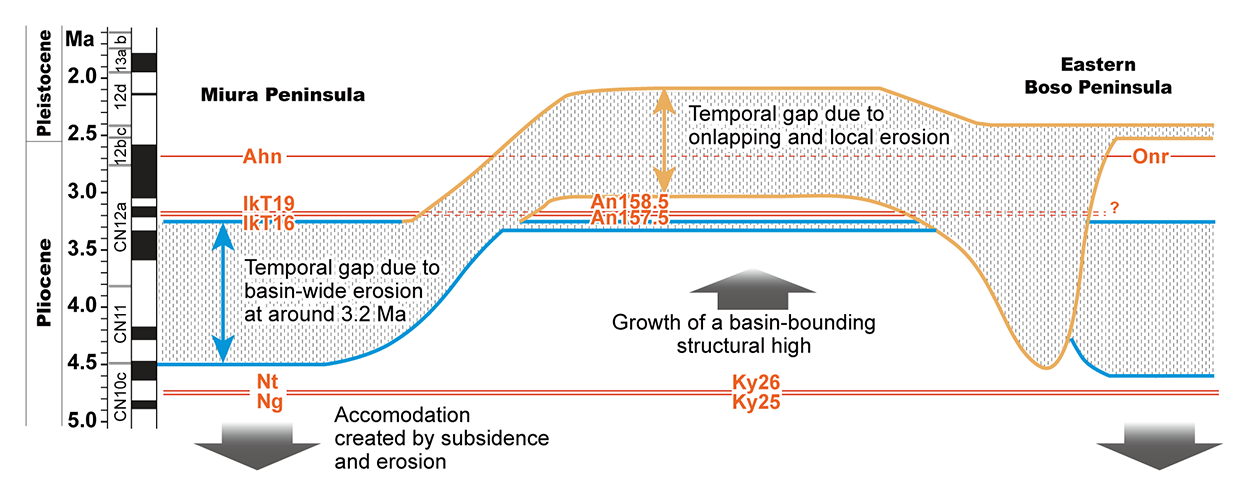
Chronostratigraphic model of the forearc basin fills exposed on the Miura and Boso peninsulas, with our interpretation of the regional relationships of subsidence and uplift that contributed to basin segmentation. The blue line indicates the age gap caused by a submarine landslide at 3.2 million years ago, and the orange line indicates the age gap due to subsequent onlap and local erosion.
The basement of the Tokyo metropolitan area consists of the Miocene–Pleistocene forearc basin fills that are well exposed around Tokyo Bay, especially on the Miura and Boso peninsulas. The forearc basin fills on these two peninsulas are called the Miura and Kazusa groups, and they were deposited during the late Miocene–Pliocene and Pliocene–middle Pleistocene, respectively. Because many biostratigraphic datum planes, paleomagnetic reversal events, and other chronostratigraphic tools are available for these deposits, they provide the “type stratigraphy” of other equivalent sedimentary sequences on the Japanese islands and in the northwest Pacific. However, the use of such stratigraphic markers has not been fully applied to understand the architecture of a basin-wide unconformity between the Miura and Kazusa groups called the Kurotaki unconformity. For our study, we made correlations among the Pliocene vitric tephra beds based on their stratigraphic levels, lithologic characteristics, the chemical compositions of glass shards, and calcareous nannofossil biostratigraphy. As a result, we were able to correlate tephra beds Ng-Ky25 just above the C3n.3n normal subchronozone (4.7 Ma), IkT16-An157.5 and IkT19-An158.5 near the top of the Mammoth reverse polarity subchronozone (3.21 Ma), and Ahn-Onr (2.6–2.7 Ma) across Tokyo Bay on the Miura and Boso peninsulas. We were able to recognize erosional surfaces and coeval mass-transport deposits immediately below the top of the Mammoth reverse polarity subchronozone, which suggests that submarine landslide(s) may have produced the lack of stratigraphic horizons (4.5–3.2 Ma) in the Miura and eastern Boso regions. Basal pebbly sandstone beds pervasively cover the erosional surfaces, and they show lateral variations into the thick (up to 60 m) mass-transport deposits and overlying turbidite sandstones. The lateral variations in sediment thickness of the post-failure deposits suggest that the basin-wide erosion was associated with the initial growth of a basin-bounding structural high that separates two distinct sub-basins in the forearc basin, which resulted in the subsequent onlapping deposition in the earliest stage of the Kazusa forearc basin. The basin-wide erosion marks the initiation of tectonic reconfigurations that led to segmentation of the forearc basin around the Tokyo Bay region.
