** Progress in Earth and Planetary Science is the official journal of the Japan Geoscience Union, published in collaboration with its 50 society members.


Gallery View of PEPS Articles
Research
Interdisciplinary research
202212202212
Washover deposits related to tsunami and storm surge along the north coast of the Shimokita Peninsula in northern Japan
Ishimura D, Ishizawa T, Yamada M, Aoki K, Sato K
Washover deposits, Tsunami, Storm surge, Shimokita Peninsula, B-Tm, To-Cu, ITRAX
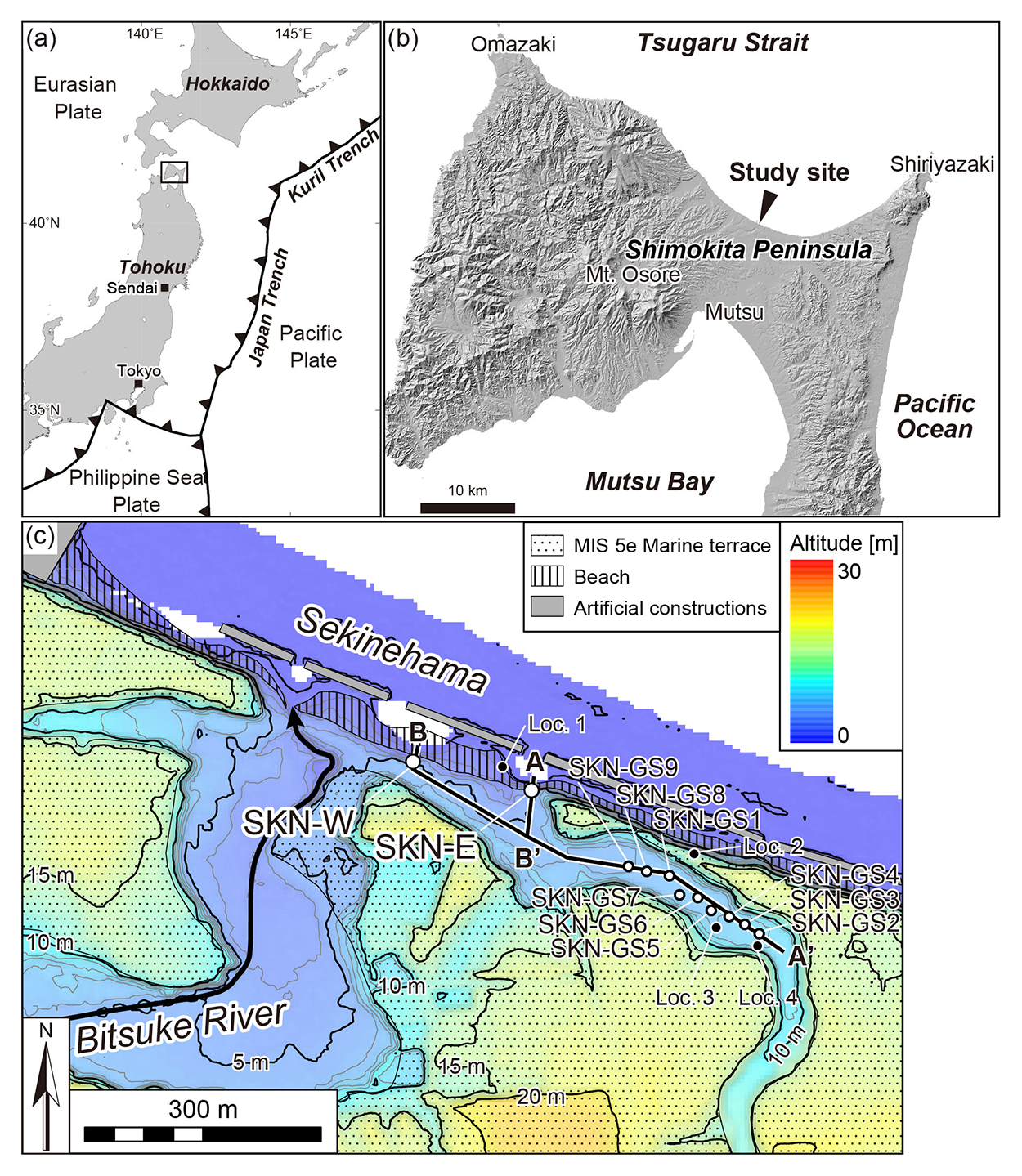
Figure 1 Study site Study site
(a) Location of the Shimokita Peninsula. Rectangle indicates area represented by Fig. 1b. (b) Northern Shimokita Peninsula. (c) Map of the Sekinehama Coast and vicinity. Intervals of gray and black contours are 1 m and 5 m, respectively. Curving arrow denotes the channel and flow direction of the Bitsuke River.

Figure 2 Lateral correlation of tsunami deposits (TD1–TD5) between coastal outcrops and SKN-GS cores.
A–A′ and B–B′ profile lines are shown in Fig. 1c. Vertical exaggeration is 25X.
A decade after the 2011 Tohoku-oki earthquake (Mw 9.0), geological surveys were conducted at multiple sites along the Pacific Coast of the tsunami-inundated Tohoku region in Japan, providing thousands of years of tsunami history. However, the challenges of correlation between historical records and geological tsunami deposits and identifying sources of historical and paleotsunamis have newly surfaced. Particularly the simultaneity and source of the 1611 Keicho tsunami in the Tohoku region and the seventeenth-century tsunami in the Hokkaido region are problematic. To solve such major issues, we conducted a tsunami-deposit survey at Sekinehama on the north coast of Shimokita Peninsula, near the junction of the Japan and Kuril trenches. We performed nondestructive analyses (X-ray computed tomography and micro-X-ray-fluorescence core scanning), grain-size analysis, tephra analysis, and radiocarbon dating of sediments from two coastal outcrops and inland drill cores. We identified five tsunami deposits (TD1–TD5) during the last 6 kyr and correlated them at a 200–400 m distance from the coast. They also correlate with previously identified tsunami deposits around the Shimokita Peninsula. From our study on tsunami deposits, we found other washover deposits in the coastal outcrops that are not represented in the inland cores. These indicate minor washover events related to small tsunamis and infrequent storm surges. The modeled age of the latest tsunami deposit is 500–300 cal yr BP (1450–1650 cal CE). This either correlates with two known tsunamis (the 1611 Keicho tsunami and another seventeenth-century tsunami) or is a previously unknown tsunami that occurred in the fifteenth–seventeenth centuries. If the latest tsunami deposit is to be accurately correlated with tsunami deposits previously identified within a 50-km distance from the study site, we need to consider an unknown fifteenth-century tsunami. Our investigation yields insights regarding the tsunami source in the vicinity of the junction of the Japan and Kuril trenches.
