** Progress in Earth and Planetary Science is the official journal of the Japan Geoscience Union, published in collaboration with its 50 society members.


Gallery View of PEPS Articles
Research
Solid earth sciences
202201202201
Right-lateral offset associated with the most recent earthquake on the Ikeda fault of the Median Tectonic Line, southwest Japan, revealed by ground-penetrating radar profiling
Patria A, Kimura H, Kitade Y, Tsutsumi H
Median Tectonic Line (MTL), Active fault, Ground-penetrating radar (GPR), 3D modeling, Earthquake geology
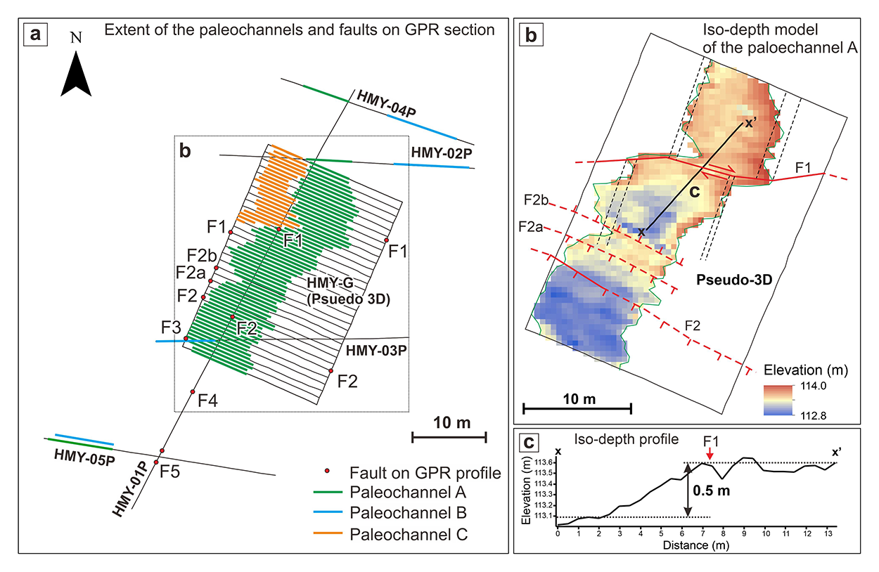
Summary of observations on the GPR sections (a) and the geometry of the deformed paleochannel A (b, c).
The Median Tectonic Line (MTL) is an arc-parallel strike-slip fault that accommodates much of the arc-parallel component of the oblique convergence of the Philippine Sea and Eurasian plates at the Nankai Trough. The MTL in Shikoku is one of the fastest-slipping faults in Japan, with a late Quaternary right-lateral slip rate of 5–10 mm/yr. To estimate the right-lateral slip amounts of the past faulting events on the MTL, we acquired 2D and pseudo-3D ground-penetrating radar (GPR) sections across the ENE-trending Ikeda fault of the MTL in eastern Shikoku. We conducted the GPR surveys at the Higashi-Miyoshi site, where two terrace riser offsets mark the active fault trace. The 2D lines were about 28–64 m long, and the pseudo-3D data were sized 20 m × 30 m with a 0.5-m inline spacing. We used 50 MHz GPR antennas and conducted wide-angle measurements to estimate the electromagnetic wave velocity. We identified three paleochannels on the final depth-converted GPR sections, and two of them are deflected by the fault. A paleochannel at 0.6–1.4 m depth is observed on all inline sections of the pseudo-3D GPR data. We built a 3D model of this paleochannel and estimated the right-lateral and vertical displacements of ~ 3.5 m and ~ 0.5 m, respectively. This paleochannel offset is probably caused by the most recent surface-rupturing earthquake on the Ikeda fault, which may be the 1596 Keicho-Fushimi earthquake. This study demonstrates the usefulness of the GPR surveys to identify geological features displaced laterally and vertically by the most recent surface-rupturing earthquake.
