** Progress in Earth and Planetary Science is the official journal of the Japan Geoscience Union, published in collaboration with its 50 society members.


Gallery View of PEPS Articles
Research
Human geosciences
202101202101
Classification of topography for ground vulnerability assessment of alluvial plains and mountains of Japan using 30 m DEM
Junko Iwahashi, Dai Yamazaki, Takayuki Nakano, Ryo Endo
Classification of topography, Terrain classification, Geomorphological map, Digital Elevation Model, Topographic measurement, Height Above the Nearest Drainage, Alluvial plain, Landslide
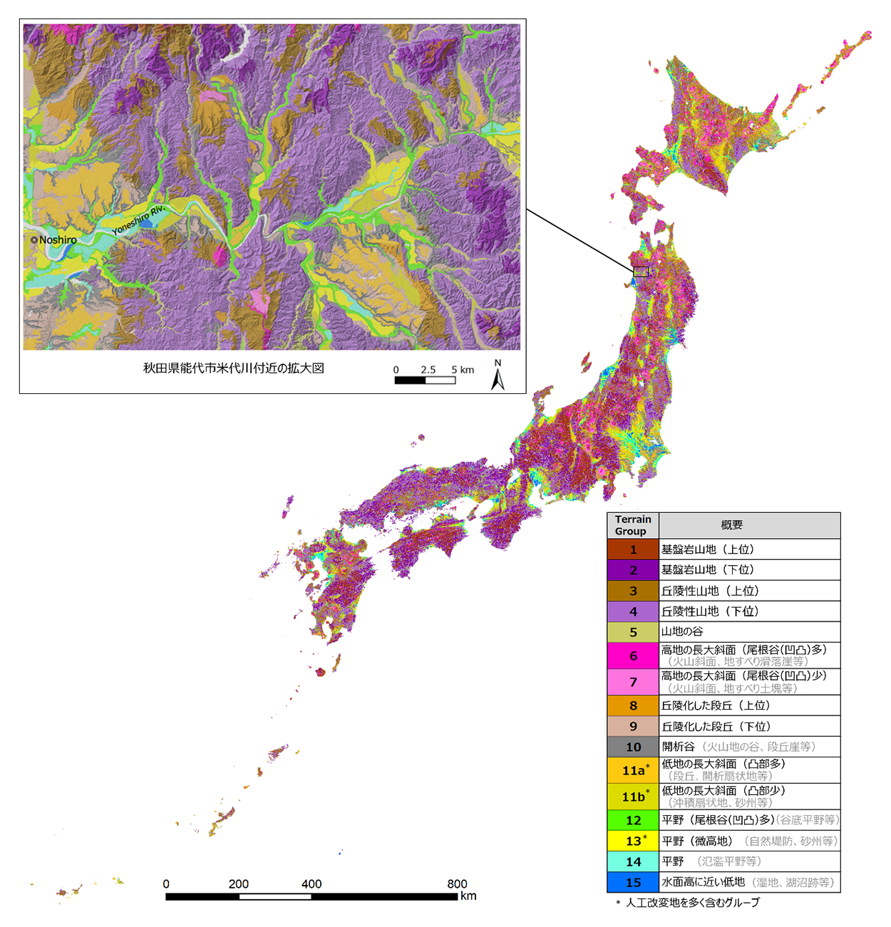
Outline images of the terrain classification of Japan (main part) created from 30-m DEM. The original data can be viewed and downloaded from the URL at the end of the text. The enlarged map near the Yoneshiro River is overlaid with shaded relief maps of GSI map tiles (created from 5-10 m DEMs). The legends, which includes many artificially modified areas, may contain polygons that are misclassified into categories different from the original forms.
This study aims to create a terrain classification of Japan that allows both geomorphological and geoengineering classifications coexist without large contradictions and to distinguish landform elements even in urban plains which include noise associated with digital elevation models (DEMs). Because Japan is susceptible to natural disasters, we designed the classification to reflect the ground vulnerability of both alluvial plains and mountains through the application of terrain classification data to landslide susceptibility and seismic zoning. We updated an existing DEM-based terrain classification method for application in the high-resolution 30 m DEM. We used topographic measurements that do not amplify manmade unevenness or noise, which are usually the main problems associated with the use of high-resolution DEMs with high vertical accuracies. We selected the height above the nearest drainage (HAND), slope gradient, surface texture, and local convexity as geometric signatures, which were devised so as not to detect noise. Segment polygon data of terrain units were derived from the raster data of slope and HAND. The polygon data were classified into 40 clusters using the attributes of slope, HAND, and surface texture; then they were grouped into 16 legends following comparisons with the existing geological and geomorphological maps and supplementary reclassification by HAND and local convexity. The derived terrain classification, except for manmade cuts and fills, showed similarities with the existing expert-driven maps and some association with areas where shallow landslides or floods frequently occur. Based on a trial in California using a 30 m DEM, we concluded that the proposed method can be adopted in other regions outside of Japan.
