** Progress in Earth and Planetary Science is the official journal of the Japan Geoscience Union, published in collaboration with its 50 society members.


Gallery View of PEPS Articles
Research
Solid earth sciences
202009202009
New Findings on Submerged Patch Reefs and Reefal Carbonate Rocks at Water Depths of 70-100 meters on the Insular Shelf off Miyako-jima, Southern Ryukyus, Japan
Inoue T, Arai K
Sub-bottom profiling (SBP), bathymetric mapping, Ryukyu Island Arc, sea-level change, submerged reef, Miyako-jima, Northwestern Pacific
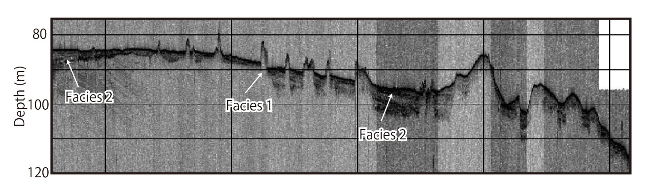
SBP profiles off the eastern side of Miyako-jima. This profile shows clear images of the mound-shaped structures.
Sub-bottom profiling (SBP) surveys and bathymetric mapping conducted off the shore of Miyako-jima, which belongs to the southern Ryukyus in the Ryukyu Island Arc, have revealed the presence of mound-shaped structures 3–8 m high and 50–120 m wide at depths of 70–100 m. The SBP surveys showed that the mounds possess strong distinct, convex upward reflector shapes at the top, which we interpret as submerged reefs and reefal sediments. Additionally, modern stratified sediment layers that cover these mound-shaped structures indicate that those reefs began forming and advancing shoreward in a back-stepping fashion as a result of sea-level rise. An analysis of the mound distribution shown by SBP and multibeam echo sounding (MBES) surveys suggest that they might have been formed during the lowstand stage of sea-level change, which includes the Last Glacial Period, because the distribution of these mounds is limited to water depths of 70 to 100 m, deeper than where present-day reefs grow. The SBP images hint that such high-resolution seismic profiles, accompanied by detailed bathymetric mapping off the reefal area, have the potential to provide effective indicators of not only coral reef paleoenvironment development, but also the tectonic setting of this offshore area.
