** Progress in Earth and Planetary Science is the official journal of the Japan Geoscience Union, published in collaboration with its 50 society members.


Gallery View of PEPS Articles
Research
Atmospheric and hydrospheric sciences
Evaluation of Satellite Precipitation Products over Central Vietnam
Trinh-Tuan L, Matsumoto J,Ngo-Duc T,Nodzu M I,Inoue T
Satellite precipitation, Central Vietnam, Vietnam Central Highlands, Vietnam Central Coast, VnGP.
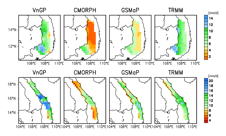
(Upper panes) Spatial patterns of four-month, 10-year averaged MJJA daily rainfall for VnGP and three SPDs over VCH in 2001-2010. (Lower panels) Same as upper panels, except for SOND rainfalls over the VCC.
A comprehensive validation of three satellite precipitation datasets (SPDs), including (1) the Climate Prediction Center Morphing algorithm (CMORPH), (2) Global Satellite Mapping of Precipitation (GSMaP) Reanalysis, and (3) Tropical Rainfall Measuring Mission multi-satellite precipitation analysis (TRMM) 3B42, was conducted using the rain gauge-based Vietnam Gridded Precipitation dataset (VnGP) and rain gauge station data for Central Vietnam. The three SPDs were compared and evaluated for two contrasting topographic regions, i.e., the Vietnam Central Highlands (VCH) and the Vietnam Central Coast (VCC), during the rainy seasons from 2001 to 2010 at different spatial (grid and regional) and temporal (daily and monthly) scales. Widespread heavy rainfall (WHR) days caused by the Northeast Winter Monsoon (NM), the Inter-tropical Convergence Zone (ITCZ), and tropical cyclones (TCs) were also identified, and the accuracies of the SPDs in detecting heavy rainfall during the WHR days were evaluated. TRMM was shown to exhibit advantages over the other SPDs, regardless of the spatial and temporal scales. Although the CMORPH and GSMaP datasets appeared to correlate moderately well with the VnGP dataset and proved able to capture the spatial distribution of rainfall characteristics in the VCC, they significantly underestimated rainfall in the VCH. Regarding the capability to reproduce WHR events, the three SPDs exhibited better performance for TCs and the ITCZ than for the NM. TRMM exhibited the best performance among the three datasets, especially for rainfall thresholds ranging from 25 to 80 mm day−1. The GSMaP and CMORPH biases showed a clear dependence on elevation and zonal wind speed, indicating the need to improve correction methods.
