** Progress in Earth and Planetary Science is the official journal of the Japan Geoscience Union, published in collaboration with its 51 society members.
** Progress in Earth and Planetary Science is partly financially supported by a Grant-in-Aid for Publication of Scientific Research Results to enhance dissemination of information of scientific research.


Gallery View of PEPS Articles
Research
Human geosciences
201803201803
Landslides triggered by an earthquake and heavy rainfalls at Aso volcano, Japan, detected by UAS and SfM-MVS photogrammetry
Saito H, Uchiyama S, Hayakawa Y S, Obanawa H
Coseismic landslides, Rainfall-induced landslides, 2016 Kumamoto earthquake, UAS, SfM-MVS photogrammetry, Aso volcano
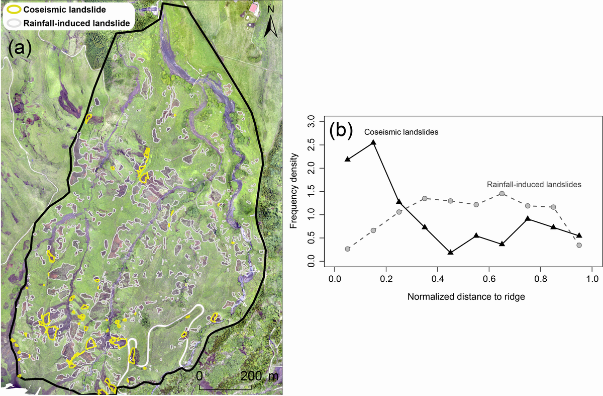
(a) Distributions of landslide initiation areas triggered by the 2016 Kumamoto earthquake (yellow polygons) and the heavy rainfalls of 2012 (white polygons) with the orthorectified images with a spatial resolution of 0.06 m, acquired in May 2016. The black polygon shows the study area. (b) Frequency density distributions of normalized distances to ridges from coseismic (black line) and rainfall-induced (gray dashed line) landslides. Normalized distances to ridges vary from 0 for a cell located on the ridge to 1 for a stream cell.
Unmanned aerial systems (UASs) and structure-from-motion multi-view stereo (SfM-MVS) photogrammetry have attracted a tremendous amount of interest for use in the creation of high-definition topographic data for geoscientific studies. By using these techniques, this study examined the topographic characteristics of coseismic landslides triggered by the 2016 Kumamoto earthquake (Mw 7.1) in the Sensuikyo area (1.0 km2) at Aso volcano, Japan. The study area has frequently experienced rainfall-induced landslide events, such as those in 1990, 2001, and 2012. We obtained orthorectified images and digital surface models (DSMs) with a spatial resolution of 0.06 m before and after the 2016 Kumamoto earthquake. By using these high-definition images and DSMs, we detected a total of 54 coseismic landslides with volumes of 9.1–3994.6 m3. These landslides, many of which initiated near topographic ridges, were typically located on upside hillslopes of previous rainfall-induced landslide scars that formed in 2012. This result suggests that the topographic effect on seismic waves, i.e., amplification of ground acceleration, was important for coseismic landslide initiation in the study area. The average depth of the coseismic landslides was 1.5 m, which is deeper than the depth of the rainfall-induced landslides prior to these. The total sediment production of the coseismic landslides reached 2.5 × 10⁴ m3/km2, which is of the same order as the sediment production triggered by the previous single heavy rainfall event. This result indicates that the effects of the 2016 Kumamoto earthquake in terms of sediment production and topographic changes were similar to those of the rainfall-induced landslide event in the study area.
