** Progress in Earth and Planetary Science is the official journal of the Japan Geoscience Union, published in collaboration with its society members.
Gallery View of PEPS Articles
Research
Human geosciences
Session convener-recommended article JpGU Meeting 2016
201801201801
Global terrain classification using 280 m DEMs: segmentation, clustering, and reclassification
Iwahashi J, Kamiya I, Matsuoka M, Yamazaki D
Geomorphological map, Terrain classification, MERIT DEM, Japan, Geomorphometry, Landform
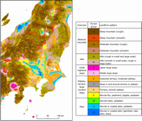
Polygon-based terrain classification data were created globally using 280 m digital elevation models (DEMs) interpolated from the multi-error-removed improved-terrain DEM (MERIT DEM). First, area segmentation was performed globally with the logarithmic value of slope gradient and the local convexity calculated from the DEM. Next, by adding surface texture, k-means clustering was performed globally and the polygons were grouped into 40 clusters. Then, we tried to reclassify these 40 clusters into geomorphologic terrain groups. In this study, we attempted reclassification and grouping using local information from Japan as a test case. The 40 clusters were compared with Japanese geological and geomorphological data and were then reclassified into 12 groups that had different geomorphological and geological characteristics. In addition, large shape landforms, mountains, and hills were subdivided by using the combined texture. Finally, 15 groups were created as terrain groups. Cross tabulations were performed with geological or lithological maps of California and Australia in order to investigate if the Japanese grouping of the clusters was also meaningful for other regions. The classification is improved from previous studies that used 1-km DEMs, especially for the representation of terrace shapes and landform elements smaller than 1 km. The results were generally suitable for distinguishing bedrock mountains, hills, large highland slopes, intermediate landforms (plateaus, terraces, large lowland slopes), and plains. On the other hand, the cross tabulations indicate that in the case of gentler landforms under different geologic provinces/climates, similar topographies may not always indicate similar formative mechanisms and lithology. This may be solved by locally replacing the legend; however, care is necessary for mixed areas where both depositional and erosional gentle plains exist. Moreover, the limit of the description of geometric signatures still appears in failure to detect narrow valley bottom plains, metropolitan areas, and slight rises in gentle plains. Therefore, both global and local perspectives regarding geologic province and climate are necessary for better grouping of the clusters, and additional parameters or higher resolution DEMs are necessary. Successful classification of terrain types of geomorphology may lead to a better understanding of terrain susceptibility to natural hazards and land development.
