** Progress in Earth and Planetary Science is the official journal of the Japan Geoscience Union, published in collaboration with its 50 society members.


Gallery View of PEPS Articles
Research
Atmospheric and hydrospheric sciences
202210202210
Subinertial frequency variations in the axis of the Tsugaru Warm Current east of the Tsugaru Strait
Kaneko H, Tanaka T, Abe H, Wakita M, Sasaki K, Miyazawa Y, Okunishi T, Watanabe S, Tatamisashi S, Sato Y
Tsugaru Strait, Tsugaru Warm Current, High-frequency radar, Data Assimilation, JCOPE, Frontal waves, Tide, Downfront wind, Baroclinic instability
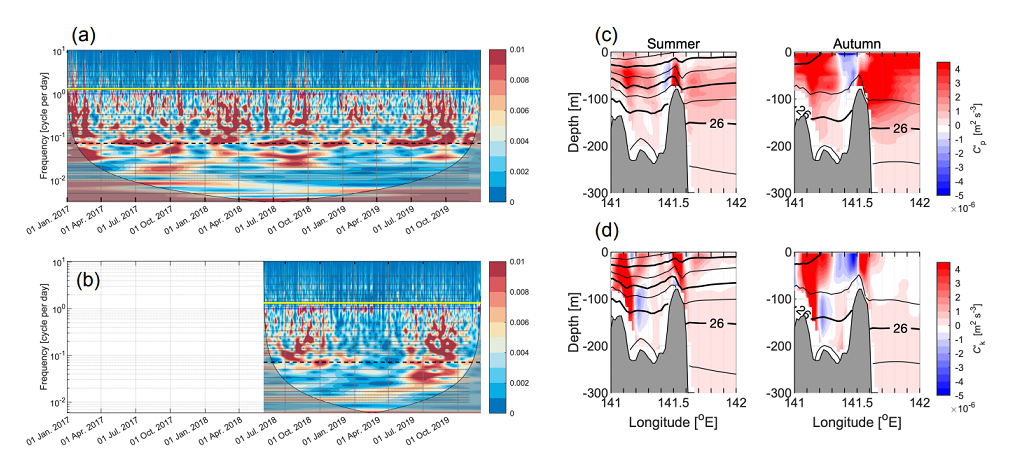
Wavelet transform of the axis of the Tsugaru Warm Current at 141.3°E calculated from (a) the high-frequency radar data and (b) the JCOPE-T DA data. The yellow line indicates the inertial frequency at 41.5°N, 1.26 cycles per day (periods of 0.75 days). The blue and black lines denote 1 and 0.07 cycles per day (periods of 1 and 14 days), respectively. Vertical distribution of the energy conversion rate calculated from the JCOPE-T DA data during 2019 (c) potential energy (upper row), and (d) kinetic energy (lower row) in summer (left column) and autumn (right column) at 41.6°N. Black contours denote the potential density anomaly, σθ [kg m-3].
The eastern part of the Tsugaru Strait (located at ~ 41.5° N) is a remarkable region of the coastal flow system around Japan due to the Tsugaru Warm Current (TgWC), an intensive eastward current that flows over its complex topography and exhibits marked tidal variation. The TgWC has a jetlike structure and demonstrates drastic seasonal changes in its path and vertical current structure. Using a high-resolution dataset obtained from a high-frequency radar system (HFR) and a coastal data assimilation experiment (JCOPE-T DA), we focused on the frontal variation, which is shorter than the seasonal timescale, along the axis of the TgWC in relation to the meanders of the jet. We found variations in the axis with multiple timescales between 1 and 14 days, especially in summer and autumn. The ~ 14-day variation, a remarkable occurrence on the west side of the eastern Tsugaru Strait, was consistent with the tidal variation in the strait. The zonal scale of the axis meander estimated by the HFR matched a scale several times larger than the internal deformation radius, especially in summer and autumn. JCOPE-T DA outputs showed that the crest of such a meander at greater depths progresses in relation to that at the surface. The outputs also suggested instabilities, indicating potential and kinetic energy conversion from the mean to the eddy field. The propagation speed of the several-day variation in the axis estimated from the HFR data was consistent with that of the two-layer baroclinic instability. The several-day variation also showed relatively high coherence with wind variation from summer to autumn, during which time the seasonal wind over the strait switched from easterly to westerly. These variations with multiple timescales imply an effect on north–south water mass mixing in the eastern part of the strait, including rapid acidification in the strait and intensification of stratification.
