** Progress in Earth and Planetary Science is the official journal of the Japan Geoscience Union, published in collaboration with its 50 society members.


Gallery View of PEPS Articles
Paper with full data attached
Human geosciences
202206202206
Global polygons for terrain classification divided into uniform slopes and basins
Junko Iwahashi, Dai Yamazaki
Geomorphological map, Terrain classification, MERIT DEM, Landform, DEM, Global, Geomorphometry, Vs30, Hydrology, HAND
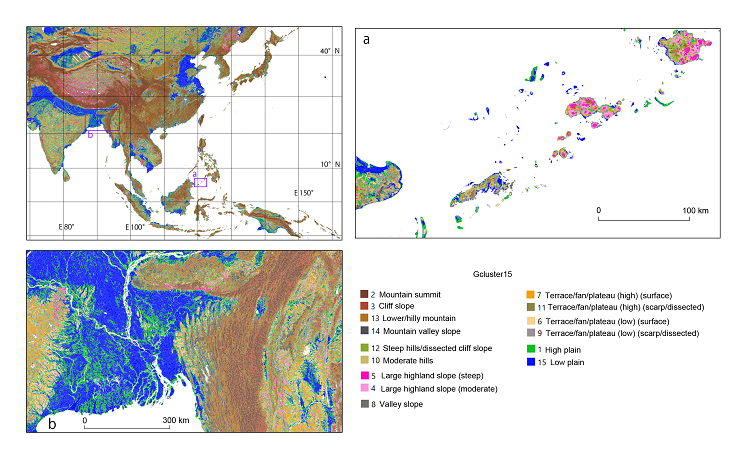
Portions of the global polygons color-coded with one of the clustering results (Gcluster15).
Global terrain classification data have been used for various issues related to topography such as the estimation of soil types and of ground vulnerability to earthquakes and the creation of seismic hazard maps. However, due to the resolution of digital elevation models (DEMs), the terrain classification data from previous studies could not discriminate small landforms such as plains at the bottom of narrow valleys and small rises in plains. Owing to the greater regional variation of small landforms, there is trade-off between DEMs of higher resolution and the creation of global geomorphological legends. To address this problem, we first merged regions with similar topographic characteristics using slope gradients and HAND (height above the nearest drainage) calculated by the 90-m-spatial-resolution DEMs interpolated from the multi-error-removed improved-terrain DEM (MERIT DEM), and united the polygons with the unit catchments of the MERIT-Basins dataset, so that the polygons contain calculated terrain measurements (slope gradient, HAND, surface texture, local convexity, sinks) and noise types as attributes, as well as the ID number of the unit catchment. In addition, we performed k-means clustering on the dataset using slope gradient, HAND, and surface texture, which can be combined with the dataset as a simple terrain classification. The clustering results were prepared in 15 and 40 global uniform clusters and 15 and 40 clusters for each basin to understand the global appearance of the terrain and provide zoning data for regional problem-solving. The 15 clusters were prepared to observe the outline of the terrain without any processing, whereas the 40 clusters were prepared to group and reclassify the polygons to create zoning data for each region. This dataset showed improvements in terms of capturing the small rises in plains compared to the authors' previous global terrain classification data. This dataset can be used as a proxy and is expected to contribute to modeling and estimation in various applications that are known to be related to topography. The datasets of this article are available at [https://gisstar.gsi.go.jp/terrain2021/].
