** Progress in Earth and Planetary Science is the official journal of the Japan Geoscience Union, published in collaboration with its 50 society members.


Gallery View of PEPS Articles
Research
Human geosciences
202103202103
Comparison of length and dynamics of wood pieces in streams covered with coniferous and broadleaf forests mapped using orthophotos acquired by an unmanned aerial vehicle
Tsunetaka H, Mtibaa S, Asano S, Okamoto T, Kurokawa U
UAV, Wood piece, Debris flow, Landslide
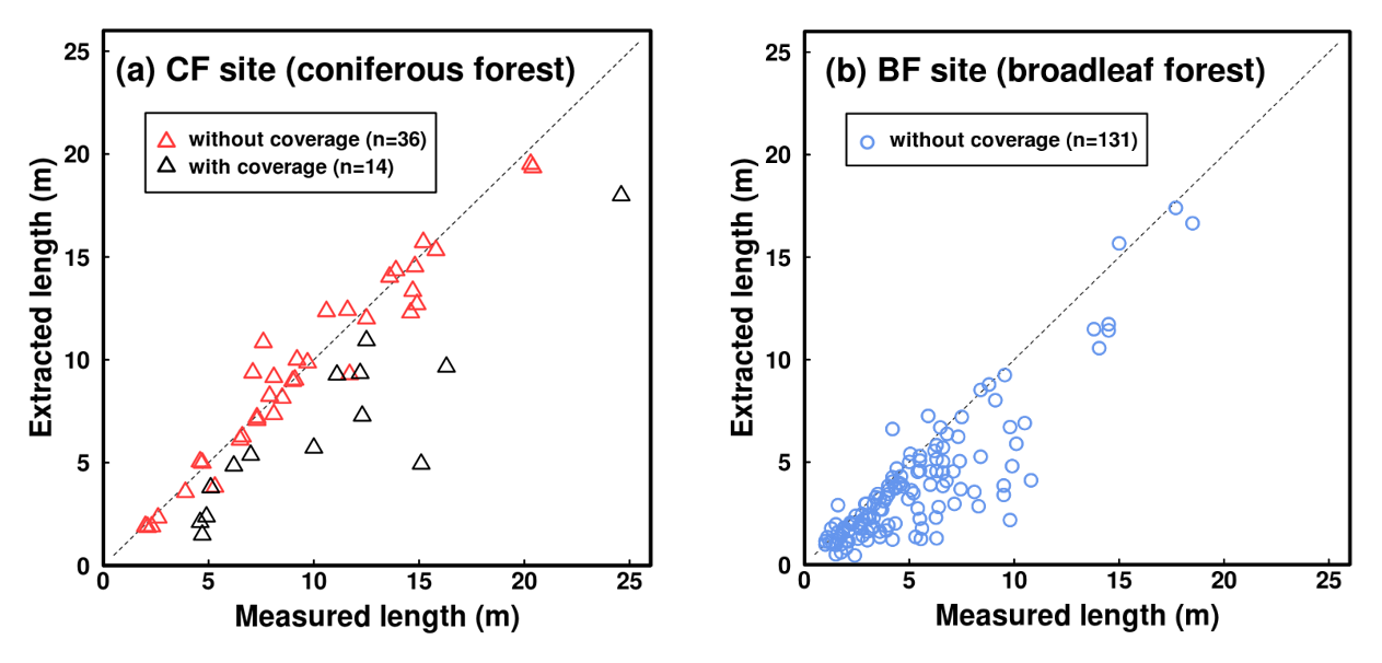
Comparison between extracted and measured lengths of wood pieces: (a) the coniferous forest (CF) site and (b) the broadleaf forest (BF) site.
As wood pieces supplied by landslides and debris flows are one of the main components of ecological and geomorphic systems, the importance of quantifying the dimensions of the wood pieces is evident. However, the low accessibility of disturbed channels after debris flows generally impedes accurate and quick wood-piece investigations. Thus, remote-sensing measurements for wood pieces are necessitated. Focusing on sub-watersheds in coniferous and broadleaf forests in Japan (the CF and BF sites, respectively), we measured the lengths of wood pieces supplied by landslides (> 0.2 m length and > 0.03 m diameter) from orthophotos acquired using a small unmanned aerial vehicle (UAV). The measurement accuracy was analyzed by comparing the lengths derived from the UAV method with direct measurements. The landslides at the CF and BF sites were triggered by extremely heavy rainfalls in 2017 and 2018, respectively. UAV flights were operated during February and September 2019 at the CF site and during November 2018 and December 2019 at the BF site. Direct measurements of wood pieces were carried out on the date of the respective second flight date in each site. When both ends of a wood piece are satisfactorily extracted from an orthophoto acquired by the UAV, the wood-piece lengths at the CF site can be measured with an accuracy of approximately ±0.5 m. At the BF site, most of the extracted lengths were shorter than the directly measured lengths, probably because the complex structures of the root wad and tree crown reduced the visibility. Most wood pieces were discharged from landslide scars at the BF site, but at the CF site, approximately 750 wood pieces remained in the landslide scars approximately 19 months after the landslide occurrence. The number of wood pieces in the landslide scars of the CF site increased with increasing landslide area, suggesting that some wood pieces can be left even if large landslides occur. The lengths and locations of the entrapped wood pieces at both sites were not significantly changed between the two UAV flight dates. However, during this period, the rainfall intensities around the CF site measured by the closest rain-gauge of the Japan Meteorological Agency reached their second highest values from 1976 to 2019, which exceeded the 30-year return period. This suggests that most of the entrapped wood pieces rarely migrated even under intense rainfall.
