** Progress in Earth and Planetary Science is the official journal of the Japan Geoscience Union, published in collaboration with its 51 society members.
** Progress in Earth and Planetary Science is partly financially supported by a Grant-in-Aid for Publication of Scientific Research Results to enhance dissemination of information of scientific research.


Gallery View of PEPS Articles
Research
Solid earth sciences
Three-dimensional mapping and kinematic characterization of mass transport deposits along the outer Kumano Basin and Nankai accretionary wedge, southwest Japan
Lackey J, Moore G, Michael Strasser
Mass transport deposit, 3D, Landslide, Nankai, Accretionary, Subduction, Kinematic
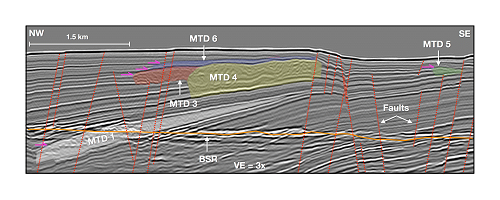
Three-dimensional (3D) seismic data from the southern Kumano Basin of southwest Japan image a nested series of moderately sized mass transport deposits (MTDs) that slid from a slope along the seaward side of the forearc basin. The deposits are dated to be approximately 0.3 to 0.9 Ma. These MTDs are likely linked to the movement along a prominent out-of-sequence thrust (OOST) fault, regionally steeper slopes that would have existed during deposition, and shifts in sedimentation over the past 0.9 Ma. The spatial resolution provided by the 3D seismic data permits the identification of kinematic characteristics and the internal geometries of the MTDs which total over 2.8 km3 in volume and cover more than 59 km2 of the seafloor at various stratigraphic levels. Each MTD is well imaged and exhibits various kinematic indicators while most of the basal glide planes and original headwall scarps above the deposits have been partially or fully eroded by subsequent MTDs. There are at least seven individual deposits that range in volume from 0.005 to 1.16 km3, in area from 0.2 to 21.8 km2; have runouts between 0.55 and 7.9 km, and generally translate downslope from the SE to NW. Basal, internal, and top surface kinematic indicators, such as grooves, thrust and fold systems, and pressure ridges, show that these MTDs originate from a prominent slide scar recognized in the high-resolution regional bathymetry. This, combined with a regionally shifting depocenter and faulting related to the earthquake cycle, points to regional tectonic activity as being the most likely failure trigger for these nested landslides.
