** Progress in Earth and Planetary Science is the official journal of the Japan Geoscience Union, published in collaboration with its 51 society members.
** Progress in Earth and Planetary Science is partly financially supported by a Grant-in-Aid for Publication of Scientific Research Results to enhance dissemination of information of scientific research.


Gallery View of PEPS Articles
Research
Human geosciences
Session convener-recommended article JpGU Meeting 2016
201710201710
Simulating and quantifying legacy topographic data uncertainty: an initial step to advancing topographic change analyses
Wasklewicz T, Zhu Z, Gares P
Stochastic models, digital terrain models, legacy data, geomorphic change detection, high-resolution topography
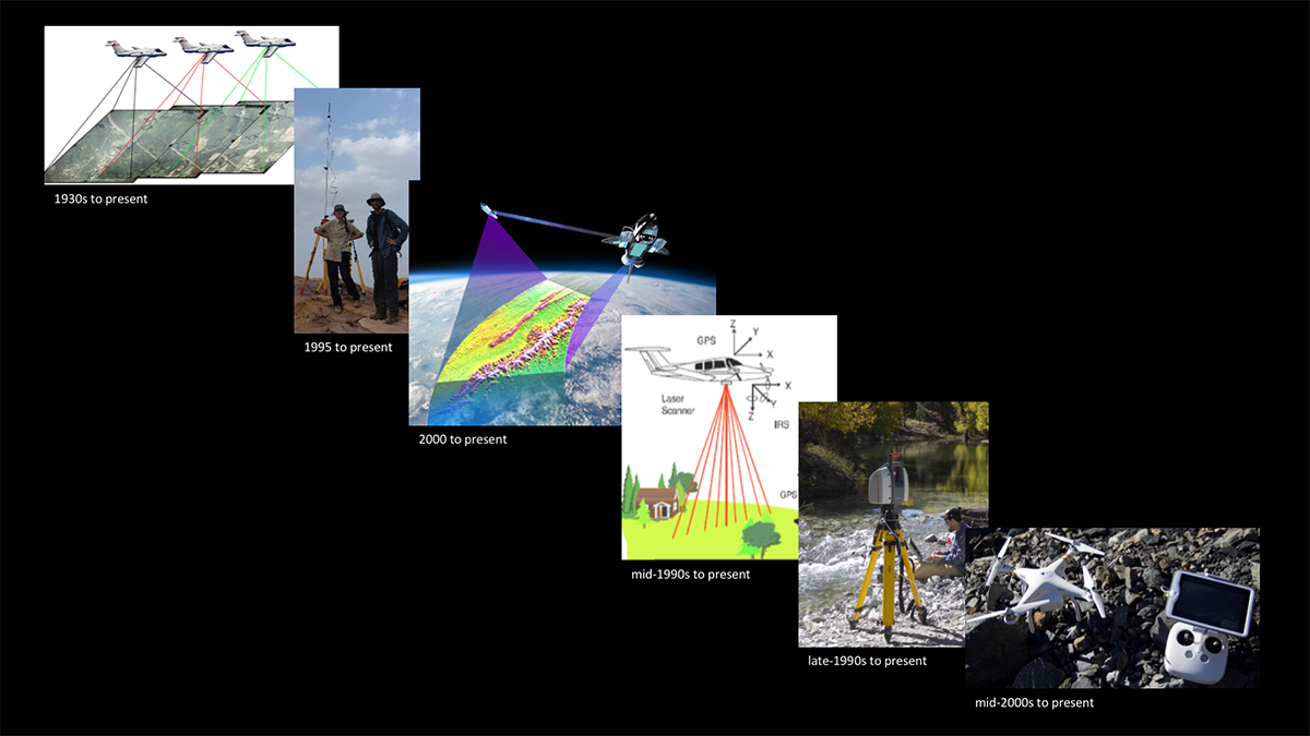
A history of methods for topographic data acquisition
Rapid technological advances, sustained funding, and a greater recognition of the value of topographic data have helped develop an increasing archive of topographic data sources. Advances in basic and applied research related to Earth surface changes require researchers to integrate recent high-resolution topography (HRT) data with the legacy datasets. Several technical challenges and data uncertainty issues persist to date when integrating legacy datasets with more recent HRT data. The disparate data sources required to extend the topographic record back in time are often stored in formats that are not readily compatible with more recent HRT data. Legacy data may also contain unknown error or unreported error that make accounting for data uncertainty difficult. There are also cases of known deficiencies in legacy datasets, which can significantly bias results. Finally, scientists are faced with the daunting challenge of definitively deriving the extent to which a landform or landscape has or will continue to change in response natural and/or anthropogenic processes. Here, we examine the question: how do we evaluate and portray data uncertainty from the varied topographic legacy sources and combine this uncertainty with current spatial data collection techniques to detect meaningful topographic changes? We view topographic uncertainty as a stochastic process that takes into consideration spatial and temporal variations from a numerical simulation and physical modeling experiment. The numerical simulation incorporates numerous topographic data sources typically found across a range of legacy data to present high-resolution data, while the physical model focuses on more recent HRT data acquisition techniques. Elevation uncertainties observed from anchor points in the digital terrain models are modeled using “states” in a stochastic estimator. Stochastic estimators trace the temporal evolution of the uncertainties and are natively capable of incorporating sensor measurements observed at various times in history. The geometric relationship between the anchor point and the sensor measurement can be approximated via spatial correlation even when a sensor does not directly observe an anchor point. Findings from a numerical simulation indicate the estimated error coincides with the actual error using certain sensors (Kinematic GNSS, ALS, TLS, and SfM-MVS). Data from 2D imagery and static GNSS did not perform as well at the time the sensor is integrated into estimator largely as a result of the low density of data added from these sources. The estimator provides a history of DEM estimation as well as the uncertainties and cross correlations observed on anchor points. Our work provides preliminary evidence that our approach is valid for integrating legacy data with HRT and warrants further exploration and field validation.
