** Progress in Earth and Planetary Science is the official journal of the Japan Geoscience Union, published in collaboration with its 51 society members.
** Progress in Earth and Planetary Science is partly financially supported by a Grant-in-Aid for Publication of Scientific Research Results to enhance dissemination of information of scientific research.


Gallery View of PEPS Articles
Research
Interdisciplinary research
201605201605
Examination of the largest-possible tsunamis (Level 2) generated along the Nankai and Suruga troughs during the past 4000 years based on studies of tsunami deposits from the 2011 Tohoku-oki tsunami
Kitamura A
Tsunami deposits, late Holocene, Suruga Trough, Nankai Trough, Shizuoka Prefecture, 2011 Tohoku-oki tsunami deposit, Level 2 tsunami
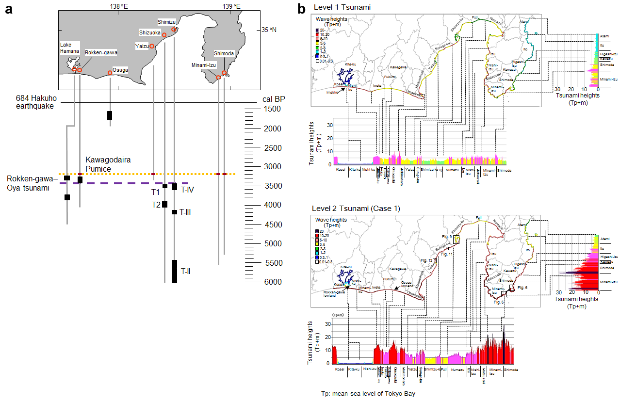
a Ages of prehistorical tsunami deposits in Shizuoka Prefecture reported in previous studies.
b Wave height (m) of Level 1 and 2 tsunamis in Shizuoka Prefecture.
Japanese historical documents reveal that Mw 8 class earthquakes have occurred every 100–150 years along the Suruga and Nankai troughs since the 684 Hakuho earthquake. These earthquakes have commonly caused large tsunamis with wave heights of up to 10 m in the Japanese coastal area along the Suruga and Nankai troughs. From the perspective of tsunami disaster management, these tsunamis are designated as Level 1 tsunamis and are the basis for the design of coastal protection facilities. A Mw 9.0 earthquake (the 2011 Tohoku-oki earthquake) and a mega-tsunami with wave heights of 10–40 m struck the Pacific coast of the northeastern Japanese mainland on 11 March 2011, and far exceeded pre-disaster predictions of wave height. Based on the lessons learned from the 2011 Tohoku-oki earthquake, the Japanese Government predicted the tsunami heights of the largest-possible tsunami (termed a Level 2 tsunami) that could be generated in the Suruga and Nankai troughs. The difference in wave heights between Level 1 and Level 2 tsunamis exceeds 20 m in some areas, including the southern Izu Peninsula. This study reviews the distribution of prehistorical tsunami deposits and tsunami boulders during the past 4000 years, based on previous studies in the coastal area of Shizuoka Prefecture, Japan. The results show that a tsunami deposit dated at 3400–3300 cal BP can be traced between the Shimizu, Shizuoka and Rokken-gawa lowlands, whereas no geologic evidence related to the corresponding tsunami (the Rokken-gawa–Oya tsunami) was found on the southern Izu Peninsula. Thus, the Rokken-gawa–Oya tsunami is not classified as a Level 2 tsunami.
